
Solid Water
The final transformation of water
Meanwhile, in the northern hemisphere at this time of year, and different transformation of water occurs, from liquid to solid. I've come to the edge of Lake Ontario in North America to see one of the most extreme examples of this transformation in action. This area is home to some of the heaviest snowfalls in the world. But it's not immediately obvious why this should be so.

Lake Ontario
An impending snowstorm is likely to be very heavy because of a unique set of conditions. The air outside is cold and dry. It's come straight from the Arctic. But this frigid air is about to be transformed. You can see what it does right below me, she is in a helicopter. Warm water. Even though it looks pretty chilly down there, the water is significantly warmer than the land around it. And there's lots of it. Even though it's frozen round the edges, there is plenty of open water in the middle. Lake Ontario is one of the great Lakes, so it's a huge body of water. Water's high heat capacity means it's held onto much of the heat it absorbed during the summer. As the cold, dry air passes over this relatively warm lake, water evaporates. As it rises over upstate New York, it forms clouds. Those clouds are the start of a special type of snowstorm, which leads to some of the biggest and fastest accumulations of snow anywhere in the world. And it's called a lake-effect snowstorm.
These snowstorms are particularly intense because the cold air can keep on blowing across a lake for days. It's like a conveyor belt of cloud formation. Within these clouds, the cold air means that water passed from liquid to its solid, crystalline state a snowflake. And they start because there are tiny grains of dust, way up in the clouds and the warm lake area provides moisture which condenses onto those droplets. And as they are carried up and up into the cloud, the temperature goes down and so they freeze into a crystal. And that Crystal is a snowflake.

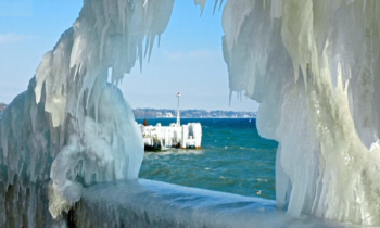
Lake Edges Frozen
Here, conditions produce a very particular type of snowflake. Because the air is so cold it produces crystals with sharper tips. These grow more branches, called dendrites. Which make the snowflakes fluffier. It's the kind of snow we all love, as long as there isn't too much of it!
It's now approaching nightfall and the snowstorm is almost upon us. How much snow falls will depend on one final factor. The wind direction. If the wind comes from the North, it passes over the narrow part of the lake and so picks up only a small amount of moisture, making just a light shower of snow. But if the wind comes from the West, it passes over almost the full length of the lake and picks up a lot of moisture, producing much more snow.
Next morning the town beside the lake wakes up to a heavy coating of snow. But because it's a regular event, people here are prepared. Across the northern hemisphere, the same interaction of cold land and relatively warm moisture produces many other spectacular weather phenomena.
Ice Sculptures
In January 2005, these remarkable ice sculptures formed when spraying from Lake Geneva in Switzerland was thrown up by strong winds and froze as soon as it landed. In Canada in 1998, rain falling on frozen ground turned to ice as it landed, and phenomenon known as an ice storm. It continued for 80 hours. The sheer weight of ice crushed over 1000 steel pylons, leaving 4 million people without electricity. Closer to home, frost forms which missing, underside when a saturated with moisture touches surfaces that are already frozen.
Our orbit around the Sun exposes our planet to potentially deadly radiation. But the payoff is a big one, a planet where water can be distributed across the whole Earth, providing spectacular weather and making it habitable.
